Simultaneous Localization and Mapping
134 papers with code • 0 benchmarks • 18 datasets
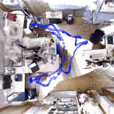
Simultaneous localization and mapping (SLAM) is the task of constructing or updating a map of an unknown environment while simultaneously keeping track of an agent's location within it.
( Image credit: ORB-SLAM2 )
Benchmarks
These leaderboards are used to track progress in Simultaneous Localization and Mapping
Libraries
Use these libraries to find Simultaneous Localization and Mapping models and implementationsDatasets
 TUM RGB-D
 Virtual KITTI
 Virtual KITTI 2
 InteriorNet
 New College
 TUM monoVO
 S3E
S3E


Most implemented papers
Visual-Inertial Monocular SLAM with Map Reuse
In recent years there have been excellent results in Visual-Inertial Odometry techniques, which aim to compute the incremental motion of the sensor with high accuracy and robustness.
Kimera: an Open-Source Library for Real-Time Metric-Semantic Localization and Mapping
MIT-SPARK/Kimera
•
 •
•
We provide an open-source C++ library for real-time metric-semantic visual-inertial Simultaneous Localization And Mapping (SLAM).
ORB-SLAM2: an Open-Source SLAM System for Monocular, Stereo and RGB-D Cameras
We present ORB-SLAM2 a complete SLAM system for monocular, stereo and RGB-D cameras, including map reuse, loop closing and relocalization capabilities.
Sparse-to-Dense: Depth Prediction from Sparse Depth Samples and a Single Image
fangchangma/sparse-to-dense
•
 •
•
We consider the problem of dense depth prediction from a sparse set of depth measurements and a single RGB image.
Online Spatial Concept and Lexical Acquisition with Simultaneous Localization and Mapping
We have proposed a nonparametric Bayesian spatial concept acquisition model (SpCoA).
Incremental Visual-Inertial 3D Mesh Generation with Structural Regularities
MIT-SPARK/Kimera
•
•
We propose instead to tightly couple mesh regularization and state estimation by detecting and enforcing structural regularities in a novel factor-graph formulation.
LiDARTag: A Real-Time Fiducial Tag System for Point Clouds
Because of the LiDAR sensors' nature, rapidly changing ambient lighting will not affect the detection of a LiDARTag; hence, the proposed fiducial marker can operate in a completely dark environment.
EndoMapper dataset of complete calibrated endoscopy procedures
Computer-assisted systems are becoming broadly used in medicine.
3D Dynamic Scene Graphs: Actionable Spatial Perception with Places, Objects, and Humans
MIT-SPARK/Kimera
•
•
Our second contribution is to provide the first fully automatic Spatial PerceptIon eNgine(SPIN) to build a DSG from visual-inertial data.
DXSLAM: A Robust and Efficient Visual SLAM System with Deep Features
For visual SLAM algorithms, though the theoretical framework has been well established for most aspects, feature extraction and association is still empirically designed in most cases, and can be vulnerable in complex environments.
