Search Results for author:
Found 52 papers, 17 papers with code
GEOBIND: Binding Text, Image, and Audio through Satellite Images
In this work, we present a deep-learning model, GeoBind, that can infer about multiple modalities, specifically text, image, and audio, from satellite imagery of a location.
GeoSynth: Contextually-Aware High-Resolution Satellite Image Synthesis
We present GeoSynth, a model for synthesizing satellite images with global style and image-driven layout control.


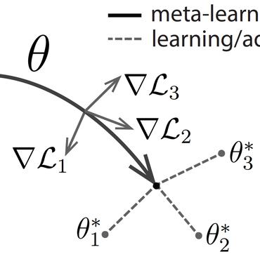
Learning Interpretable Policies in Hindsight-Observable POMDPs through Partially Supervised Reinforcement Learning
At the heart of PSRL is the fusion of both supervised and unsupervised learning.


LD-SDM: Language-Driven Hierarchical Species Distribution Modeling
Further, we propose a novel proximity-aware evaluation metric that enables evaluating species distribution models using any pixel-level representation of ground-truth species range map.

Eroding Trust In Aerial Imagery: Comprehensive Analysis and Evaluation Of Adversarial Attacks In Geospatial Systems
In critical operations where aerial imagery plays an essential role, the integrity and trustworthiness of data are paramount.
BirdSAT: Cross-View Contrastive Masked Autoencoders for Bird Species Classification and Mapping
We propose a metadata-aware self-supervised learning~(SSL)~framework useful for fine-grained classification and ecological mapping of bird species around the world.

Vision-Language Pseudo-Labels for Single-Positive Multi-Label Learning
In general multi-label learning, a model learns to predict multiple labels or categories for a single input image.

A Partially Supervised Reinforcement Learning Framework for Visual Active Search
Visual active search (VAS) has been proposed as a modeling framework in which visual cues are used to guide exploration, with the goal of identifying regions of interest in a large geospatial area.
FroSSL: Frobenius Norm Minimization for Efficient Multiview Self-Supervised Learning
However, these two approaches are difficult to combine due to the computational complexity of computing eigenvalues.


Learning Tri-modal Embeddings for Zero-Shot Soundscape Mapping
We focus on the task of soundscape mapping, which involves predicting the most probable sounds that could be perceived at a particular geographic location.
 Ranked #1 on
Cross-Modal Retrieval
on SoundingEarth
(using extra training data)
Ranked #1 on
Cross-Modal Retrieval
on SoundingEarth
(using extra training data)
StereoFlowGAN: Co-training for Stereo and Flow with Unsupervised Domain Adaptation
We introduce a novel training strategy for stereo matching and optical flow estimation that utilizes image-to-image translation between synthetic and real image domains.


Sat2Cap: Mapping Fine-Grained Textual Descriptions from Satellite Images
For a given location and overhead image, our model predicts the expected CLIP embeddings of the ground-level scenery.
Fine-Grained Property Value Assessment using Probabilistic Disaggregation
The monetary value of a given piece of real estate, a parcel, is often readily available from a geographic information system.
A Visual Active Search Framework for Geospatial Exploration
Many problems can be viewed as forms of geospatial search aided by aerial imagery, with examples ranging from detecting poaching activity to human trafficking.

Geo-Information Harvesting from Social Media Data
In this article, we address key aspects in the field, including data availability, analysis-ready data preparation and data management, geo-information extraction from social media text messages and images, and the fusion of social media and remote sensing data.
Causality for Inherently Explainable Transformers: CAT-XPLAIN
There have been several post-hoc explanation approaches developed to explain pre-trained black-box neural networks.
Revisiting Near/Remote Sensing with Geospatial Attention
We introduce a novel architecture for near/remote sensing that is based on geospatial attention and demonstrate its use for five segmentation tasks.
Dynamic Feature Alignment for Semi-supervised Domain Adaptation
Most research on domain adaptation has focused on the purely unsupervised setting, where no labeled examples in the target domain are available.
Intensity Harmonization for Airborne LiDAR
We show that our method performs as well as the best baseline in areas with similar intensity distributions, and outperforms all baselines in areas with different intensity distributions.
Towards a Collective Agenda on AI for Earth Science Data Analysis
In the last years we have witnessed the fields of geosciences and remote sensing and artificial intelligence to become closer.
Content-Aware Detection of Temporal Metadata Manipulation
Finally, we demonstrate how the proposed method can be employed to estimate a possible time-of-capture in scenarios in which the timestamp is missing from the metadata.

Learning a Dynamic Map of Visual Appearance
The appearance of the world varies dramatically not only from place to place but also from hour to hour and month to month.
A Structure-Aware Method for Direct Pose Estimation
Direct methods, such as PoseNet, regress pose from the image as a fixed function, for example using a feed-forward convolutional network.


Dynamic Traffic Modeling From Overhead Imagery
Our goal is to use overhead imagery to understand patterns in traffic flow, for instance answering questions such as how fast could you traverse Times Square at 3am on a Sunday.
Optical Wavelength Guided Self-Supervised Feature Learning For Galaxy Cluster Richness Estimate
We believe the proposed method will benefit astronomy and cosmology, where a large number of unlabeled multi-band images are available, but acquiring image labels is costly.
Dynamic Image for 3D MRI Image Alzheimer's Disease Classification
We propose to apply a 2D CNN architecture to 3D MRI image Alzheimer's disease classification.


Contrastive Cross-Modal Pre-Training: A General Strategy for Small Sample Medical Imaging
A key challenge in training neural networks for a given medical imaging task is often the difficulty of obtaining a sufficient number of manually labeled examples.
Improved Trainable Calibration Method for Neural Networks on Medical Imaging Classification
Recent works have shown that deep neural networks can achieve super-human performance in a wide range of image classification tasks in the medical imaging domain.
Single Image Cloud Detection via Multi-Image Fusion
A primary challenge in developing algorithms for identifying such artifacts is the cost of collecting annotated training data.
Estimating Displaced Populations from Overhead
We introduce a deep learning approach to perform fine-grained population estimation for displacement camps using high-resolution overhead imagery.
RasterNet: Modeling Free-Flow Speed using LiDAR and Overhead Imagery
Roadway free-flow speed captures the typical vehicle speed in low traffic conditions.
Unsupervised Domain Adaptation for Mammogram Image Classification: A Promising Tool for Model Generalization
Generalization is one of the key challenges in the clinical validation and application of deep learning models to medical images.
Joint 2D-3D Breast Cancer Classification
Breast cancer is the malignant tumor that causes the highest number of cancer deaths in females.
Defense-PointNet: Protecting PointNet Against Adversarial Attacks
Despite remarkable performance across a broad range of tasks, neural networks have been shown to be vulnerable to adversarial attacks.
2D Convolutional Neural Networks for 3D Digital Breast Tomosynthesis Classification
Automated methods for breast cancer detection have focused on 2D mammography and have largely ignored 3D digital breast tomosynthesis (DBT), which is frequently used in clinical practice.
Learning to Map Nearly Anything
Looking at the world from above, it is possible to estimate many properties of a given location, including the type of land cover and the expected land use.
Learning Geo-Temporal Image Features
We propose to implicitly learn to extract geo-temporal image features, which are mid-level features related to when and where an image was captured, by explicitly optimizing for a set of location and time estimation tasks.
Remote Estimation of Free-Flow Speeds
We propose an automated method to estimate a road segment's free-flow speed from overhead imagery and road metadata.
FARSA: Fully Automated Roadway Safety Assessment
An emerging approach for conducting such assessments in the United States is through the US Road Assessment Program (usRAP), which rates roads from highest risk (1 star) to lowest (5 stars).
A Weakly Supervised Approach for Estimating Spatial Density Functions from High-Resolution Satellite Imagery
We propose a neural network component, the regional aggregation layer, that makes it possible to train a pixel-level density estimator using only coarse-grained density aggregates, which reflect the number of objects in an image region.
What Goes Where: Predicting Object Distributions from Above
In this work, we propose a cross-view learning approach, in which images captured from a ground-level view are used as weakly supervised annotations for interpreting overhead imagery.
Learning to Look around Objects for Top-View Representations of Outdoor Scenes
Given a single RGB image of a complex outdoor road scene in the perspective view, we address the novel problem of estimating an occlusion-reasoned semantic scene layout in the top-view.

A Unified Model for Near and Remote Sensing
To evaluate our approach, we created a large dataset of overhead and ground-level images from a major urban area with three sets of labels: land use, building function, and building age.
Revisiting IM2GPS in the Deep Learning Era
The recent state-of-the-art approach to this problem is a deep image classification approach in which the world is spatially divided into cells and a deep network is trained to predict the correct cell for a given image.
 Ranked #1 on
Photo geolocation estimation
on Im2GPS
(Reference images metric)
Ranked #1 on
Photo geolocation estimation
on Im2GPS
(Reference images metric)
Understanding and Mapping Natural Beauty
While natural beauty is often considered a subjective property of images, in this paper, we take an objective approach and provide methods for quantifying and predicting the scenicness of an image.
Predicting Ground-Level Scene Layout from Aerial Imagery
We use our network to address the task of estimating the geolocation and geoorientation of a ground image.
![]() Ranked #6 on
Cross-View Image-to-Image Translation
on cvusa
Ranked #6 on
Cross-View Image-to-Image Translation
on cvusa
Detecting Vanishing Points using Global Image Context in a Non-Manhattan World
Our method reverses this process: we propose a set of horizon line candidates and score each based on the vanishing points it contains.
 Ranked #2 on
Horizon Line Estimation
on York Urban Dataset
Ranked #2 on
Horizon Line Estimation
on York Urban Dataset
Horizon Lines in the Wild
The horizon line is an important contextual attribute for a wide variety of image understanding tasks.
 Ranked #2 on
Horizon Line Estimation
on Horizon Lines in the Wild
Ranked #2 on
Horizon Line Estimation
on Horizon Lines in the Wild
Building Dynamic Cloud Maps From the Ground Up
Satellite imagery of cloud cover is extremely important for understanding and predicting weather.
Wide-Area Image Geolocalization with Aerial Reference Imagery
We propose to use deep convolutional neural networks to address the problem of cross-view image geolocalization, in which the geolocation of a ground-level query image is estimated by matching to georeferenced aerial images.
Cloud Motion as a Calibration Cue
We propose cloud motion as a natural scene cue that enables geometric calibration of static outdoor cameras.
Shadow Estimation Method for "The Episolar Constraint: Monocular Shape from Shadow Correspondence"
We show these approaches only work with very careful tuning of parameters, and do not work well for long-term time-lapse sequences taken over the span of many months.
