Search Results for author:
Found 19 papers, 2 papers with code
Leveraging feature communication in federated learning for remote sensing image classification
In the realm of Federated Learning (FL) applied to remote sensing image classification, this study introduces and assesses several innovative communication strategies.


Insight Into the Collocation of Multi-Source Satellite Imagery for Multi-Scale Vessel Detection
To overcome this issue, this paper focused on the DL models trained on datasets that consist of different optical images and a combination of radar and optical data.
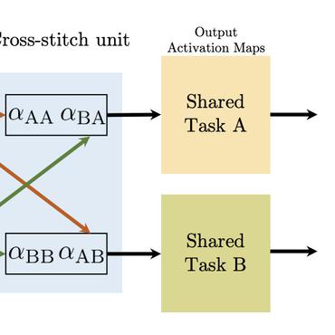
Data exploitation: multi-task learning of object detection and semantic segmentation on partially annotated data
Multi-task partially annotated data where each data point is annotated for only a single task are potentially helpful for data scarcity if a network can leverage the inter-task relationship.
Self-Training and Multi-Task Learning for Limited Data: Evaluation Study on Object Detection
Experimental results show the improvement of performance when using a weak teacher with unseen data for training a multi-task student.
Burnt area extraction from high-resolution satellite images based on anomaly detection
Wildfire detection using satellite images is a widely studied task in remote sensing with many applications to fire delineation and mapping.

Knowledge Distillation for Object Detection: from generic to remote sensing datasets
Knowledge distillation, a well-known model compression technique, is an active research area in both computer vision and remote sensing communities.
Multimodal Object Detection in Remote Sensing
Object detection in remote sensing is a crucial computer vision task that has seen significant advancements with deep learning techniques.
Weakly supervised marine animal detection from remote sensing images using vector-quantized variational autoencoder
This paper studies a reconstruction-based approach for weakly-supervised animal detection from aerial images in marine environments.
Object counting from aerial remote sensing images: application to wildlife and marine mammals
Anthropogenic activities pose threats to wildlife and marine fauna, prompting the need for efficient animal counting methods.
Joint multi-modal Self-Supervised pre-training in Remote Sensing: Application to Methane Source Classification
In earth observation, there are opportunities to exploit domain-specific remote sensing image data in order to improve these methods.
Spherical Sliced-Wasserstein
Many variants of the Wasserstein distance have been introduced to reduce its original computational burden.
Learning Digital Terrain Models from Point Clouds: ALS2DTM Dataset and Rasterization-based GAN
Despite the popularity of deep neural networks in various domains, the extraction of digital terrain models (DTMs) from airborne laser scanning (ALS) point clouds is still challenging.
Very high resolution Airborne PolSAR Image Classification using Convolutional Neural Networks
In this work, we exploit convolutional neural networks (CNNs) for the classification of very high resolution (VHR) polarimetric SAR (PolSAR) data.

Vehicle detection and counting from VHR satellite images: efforts and open issues
Detection of new infrastructures (commercial, logistics, industrial or residential) from satellite images constitutes a proven method to investigate and follow economic and urban growth.
Efficient texture retrieval using multiscale local extrema descriptors and covariance embedding
This paper presents an efficient method for texture retrieval using multiscale feature extraction and embedding based on the local extrema keypoints.
Classification of remote sensing images using attribute profiles and feature profiles from different trees: a comparative study
The motivation of this paper is to conduct a comparative study on remote sensing image classification using the morphological attribute profiles (APs) and feature profiles (FPs) generated from different types of tree structures.
Recent Developments from Attribute Profiles for Remote Sensing Image Classification
Morphological attribute profiles (APs) are among the most effective methods to model the spatial and contextual information for the analysis of remote sensing images, especially for classification task.
Buried object detection from B-scan ground penetrating radar data using Faster-RCNN
In this paper, we adapt the Faster-RCNN framework for the detection of underground buried objects (i. e. hyperbola reflections) in B-scan ground penetrating radar (GPR) images.
Texture and Color-based Image Retrieval Using the Local Extrema Features and Riemannian Distance
A novel efficient method for content-based image retrieval (CBIR) is developed in this paper using both texture and color features.
