Towards Space-to-Ground Data Availability for Agriculture Monitoring
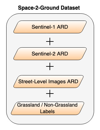
The recent advances in machine learning and the availability of free and open big Earth data (e.g., Sentinel missions), which cover large areas with high spatial and temporal resolution, have enabled many agriculture monitoring applications. One example is the control of subsidy allocations of the Common Agricultural Policy (CAP). Advanced remote sensing systems have been developed towards the large-scale evidence-based monitoring of the CAP. Nevertheless, the spatial resolution of satellite images is not always adequate to make accurate decisions for all fields. In this work, we introduce the notion of space-to-ground data availability, i.e., from the satellite to the field, in an attempt to make the best out of the complementary characteristics of the different sources. We present a space-to-ground dataset that contains Sentinel-1 radar and Sentinel-2 optical image time-series, as well as street-level images from the crowdsourcing platform Mapillary, for grassland fields in the area of Utrecht for 2017. The multifaceted utility of our dataset is showcased through the downstream task of grassland classification. We train machine and deep learning algorithms on these different data domains and highlight the potential of fusion techniques towards increasing the reliability of decisions.
PDF Abstract


