Search Results for author:
Found 23 papers, 13 papers with code
There Are No Data Like More Data- Datasets for Deep Learning in Earth Observation
We hope to contribute to an understanding that the nature of our data is what distinguishes the Earth observation community from many other communities that apply deep learning techniques to image data, and that a detailed understanding of EO data peculiarities is among the core competencies of our discipline.
A Benchmarking Protocol for SAR Colorization: From Regression to Deep Learning Approaches
To our knowledge, this is the first attempt to propose a research line for SAR colorization that includes a protocol, a benchmark, and a complete performance evaluation.

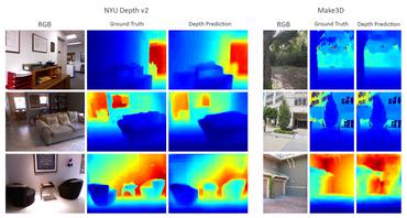
Probabilistic MIMO U-Net: Efficient and Accurate Uncertainty Estimation for Pixel-wise Regression
For that purpose, we adapted the U-Net architecture to train multiple subnetworks within a single model, harnessing the overparameterization in deep neural networks.

UnCRtainTS: Uncertainty Quantification for Cloud Removal in Optical Satellite Time Series
Clouds and haze often occlude optical satellite images, hindering continuous, dense monitoring of the Earth's surface.
 Ranked #1 on
Cloud Removal
on SEN12MS-CR
Ranked #1 on
Cloud Removal
on SEN12MS-CR

Explaining Multimodal Data Fusion: Occlusion Analysis for Wilderness Mapping
Jointly harnessing complementary features of multi-modal input data in a common latent space has been found to be beneficial long ago.
MapInWild: A Remote Sensing Dataset to Address the Question What Makes Nature Wild
Antrophonegic pressure (i. e. human influence) on the environment is one of the largest causes of the loss of biological diversity.
EOD: The IEEE GRSS Earth Observation Database
In the era of deep learning, annotated datasets have become a crucial asset to the remote sensing community.
SEN12MS-CR-TS: A Remote Sensing Data Set for Multi-modal Multi-temporal Cloud Removal
About half of all optical observations collected via spaceborne satellites are affected by haze or clouds.
 Ranked #3 on
Cloud Removal
on SEN12MS-CR-TS
Ranked #3 on
Cloud Removal
on SEN12MS-CR-TS
Deep-Learning-Based Single-Image Height Reconstruction from Very-High-Resolution SAR Intensity Data
Originally developed in fields such as robotics and autonomous driving with image-based navigation in mind, deep learning-based single-image depth estimation (SIDE) has found great interest in the wider image analysis community.

There is no data like more data -- current status of machine learning datasets in remote sensing
Annotated datasets have become one of the most crucial preconditions for the development and evaluation of machine learning-based methods designed for the automated interpretation of remote sensing data.
Remote Sensing Image Classification with the SEN12MS Dataset
Using that, we provide results for several baseline models based on two standard CNN architectures and different input data configurations.

Spatially Resolving the Enhancement Effect in Surface-Enhanced Coherent Anti-Stokes Raman Scattering by Plasmonic Doppler Gratings
In this work, we introduce the platform of plasmonic Doppler grating (PDG) to experimentally investigate the enhancement effect of plasmonic gratings in the input and output beams of nonlinear surface-enhanced coherent anti-Stokes Raman scattering (SECARS).
Optics Mesoscale and Nanoscale Physics Materials Science Other Condensed Matter Chemical Physics
Synthesizing Optical and SAR Imagery From Land Cover Maps and Auxiliary Raster Data
We synthesize both optical RGB and synthetic aperture radar (SAR) remote sensing images from land cover maps and auxiliary raster data using generative adversarial networks (GANs).

Multi-task Learning for Human Settlement Extent Regression and Local Climate Zone Classification
Human Settlement Extent (HSE) and Local Climate Zone (LCZ) maps are both essential sources, e. g., for sustainable urban development and Urban Heat Island (UHI) studies.

Multi-Sensor Data Fusion for Cloud Removal in Global and All-Season Sentinel-2 Imagery
This work has been accepted by IEEE TGRS for publication.
Cloud removal in Sentinel-2 imagery using a deep residual neural network and SAR-optical data fusion
Optical remote sensing imagery is at the core of many Earth observation activities.
Ranked #3 on
Cloud Removal
on SEN12MS-CR
Multi-level Feature Fusion-based CNN for Local Climate Zone Classification from Sentinel-2 Images: Benchmark Results on the So2Sat LCZ42 Dataset
As a unique classification scheme for urban forms and functions, the local climate zone (LCZ) system provides essential general information for any studies related to urban environments, especially on a large scale.
Weakly Supervised Semantic Segmentation of Satellite Images for Land Cover Mapping -- Challenges and Opportunities
Therefore, this paper seeks to make a case for the application of weakly supervised learning strategies to get the most out of available data sources and achieve progress in high-resolution large-scale land cover mapping.
 Weakly-supervised Learning
Weakly supervised Semantic Segmentation
+1
Weakly-supervised Learning
Weakly supervised Semantic Segmentation
+1
So2Sat LCZ42: A Benchmark Dataset for Global Local Climate Zones Classification
This is especially true for an automated analysis of remote sensing images on a global scale, which enables us to address global challenges such as urbanization and climate change using state-of-the-art machine learning techniques.
BIG-bench Machine Learning
Cultural Vocal Bursts Intensity Prediction
+1
SEN12MS -- A Curated Dataset of Georeferenced Multi-Spectral Sentinel-1/2 Imagery for Deep Learning and Data Fusion
The availability of curated large-scale training data is a crucial factor for the development of well-generalizing deep learning methods for the extraction of geoinformation from multi-sensor remote sensing imagery.
A Conditional Generative Adversarial Network to Fuse Sar And Multispectral Optical Data For Cloud Removal From Sentinel-2 Images
In this paper, we present the first conditional generative adversarial network (cGAN) architecture that is specifically designed to fuse synthetic aperture radar (SAR) and optical multi-spectral (MS) image data to generate cloud- and haze-free MS optical data from a cloud-corrupted MS input and an auxiliary SAR image.
Ranked #5 on
Cloud Removal
on SEN12MS-CR
The SEN1-2 Dataset for Deep Learning in SAR-Optical Data Fusion
While deep learning techniques have an increasing impact on many technical fields, gathering sufficient amounts of training data is a challenging problem in remote sensing.
Identifying Corresponding Patches in SAR and Optical Images with a Pseudo-Siamese CNN
In this letter, we propose a pseudo-siamese convolutional neural network (CNN) architecture that enables to solve the task of identifying corresponding patches in very-high-resolution (VHR) optical and synthetic aperture radar (SAR) remote sensing imagery.
